


PT-108
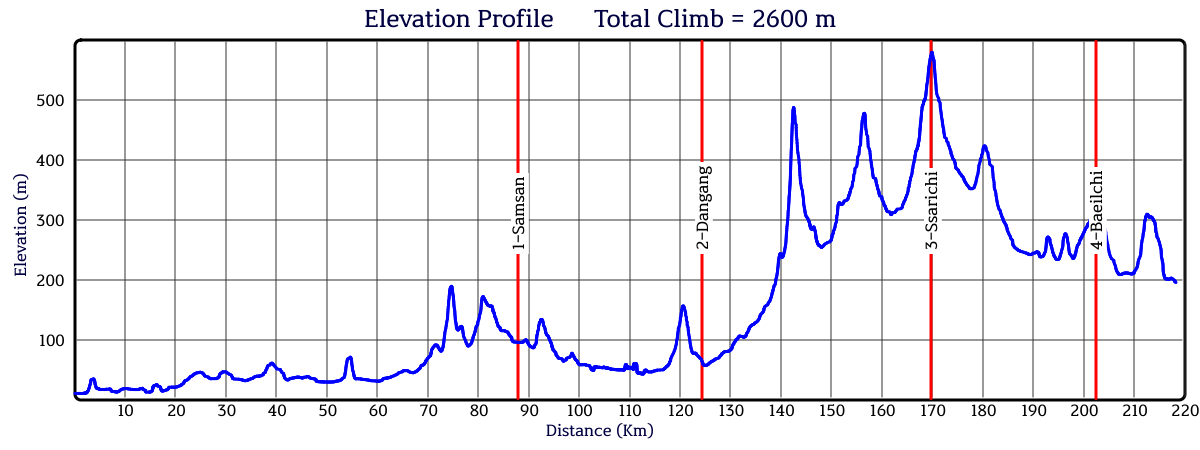
218km 2,600m
Last Update : 2026. 4. 23
단종 어드벤처 Danjong Adventure
출발점 Start location
서울 광나루 인증센터
Seoul Gwangnaru 4daegang stamp post
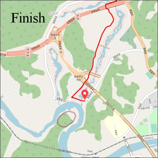
도착점 Finish location
영월읍 청령포 매표소
Yeongwol, Cheongnyeongpo Ticket office
이 퍼머넌트는 "어드벤처 시리즈" 중 하나입니다. 어드벤처 퍼머넌트는 험난하고, 오지의 작은 길을 달리며 한국의 가장 아름다운 경치를 보여줍니다. 참가자들은 좋은 컨디션과 완벽한 준비가 필요합니다. 항상 조심해야 합니다. 만약 날씨가 좋지 않다면 진행이 어려울 수 있습니다. 눈이 녹지 않았거나, 비가 오거나, 비가 온 직후에는 위험합니다. 도로 위의 낙석과 모래, 낙엽 등을 조심하세요. 반드시 클릿커버 또는 여분의 신발 등을 준비하세요. 림-브레이크용 카본 휠셋은 사용하지 않는 것이 좋습니다. 어드벤처 시리즈는 24개 이상의 퍼머넌트가 있습니다. 어드벤처 시리즈 중에서 각기 다른 퍼머넌트를 완주하면 세 가지 상을 받을 수 있습니다: 어드벤처-6, 어드벤처-12, 어드벤처-24 어워드. 완주기간 제한은 없습니다. 수상자는 한국 란도너스의 수상 명단에 등록되며, Adv-24 수상자에게는 기념메달이 무료로 발송됩니다. 어드벤처 퍼머넌트는 웹사이트의 "명예 및 수상 - 수상 종목" 에서 확인하세요.
This permanent is one in the "adventure series". Permanents in the adventure series are hard, using small roads in remote countryside and show the most beautiful scenery of the country. Riders must have a good condition and must be well prepared. Take care of safety at all time. If the weather condition is not good, especially after rain or snow, riding can be difficult. Please be careful of small pebbles, sand, and fallen leaves on the road. Be sure to prepare cleat-covers, etc. Carbon wheelsets with rim-breaks are not recommended. There are over 24 different adventure permanents. Three awards can be won for completing different adventure permanents at own choice: Adventure-6 award, Adventure-12 award and the Adventure-24 award. There is no date limit. The winners are listed in the 'Honor Roll' on the Korea Randonneurs website. The winner of the Adv-24 award will receive a medal (no cost). To see a list of all adventure permanents, please visit the section AWARDS in this website.
This permanent is one in the "adventure series". Permanents in the adventure series are hard, using small roads in remote countryside and show the most beautiful scenery of the country. Riders must have a good condition and must be well prepared. Take care of safety at all time. If the weather condition is not good, especially after rain or snow, riding can be difficult. Please be careful of small pebbles, sand, and fallen leaves on the road. Be sure to prepare cleat-covers, etc. Carbon wheelsets with rim-breaks are not recommended. There are over 24 different adventure permanents. Three awards can be won for completing different adventure permanents at own choice: Adventure-6 award, Adventure-12 award and the Adventure-24 award. There is no date limit. The winners are listed in the 'Honor Roll' on the Korea Randonneurs website. The winner of the Adv-24 award will receive a medal (no cost). To see a list of all adventure permanents, please visit the section AWARDS in this website.
비포장 구간 주의사항 / Gravel section warning
출발지점으로부터 167~170km 구간 싸리치길에 비포장 구간이 있습니다.There is a gravel section on the Ssarichi-gil between 167 and 170km from the starting point.
주의 | Warning

The end of the Sarichi-gil, which meets Local Route 88, is prohibited from turning left and there is no crosswalk. Participants must sufficiently slow down at the Ssarichi-gil downhill, stop safely before the junction, and get off their bicycles and walk the shortest distance under Article 10(3) of the Road Traffic Act.
달리기 전 알아두면 좋은 상식들 | Good to know before you start....
노산군으로 강등된 단종은 처소인 창덕궁에서 유배교서를 받고 돈화문을 떠나 청계천 영도교(현재 서울 동묘시장 인근)에서 정순왕후와 헤어진 뒤 화양정(현재 서울 광진구 화양동주민센터 인근)에서 하룻밤을 묵었습니다. 광나루부터 여주 이포나루에 이르는 이튿날의 물길 여정은 안전한 자전거길로 대체했습니다.출발지로부터 약 20km 지점 강 건너 하남시 배알미동의 이름은 단종이 탄 배가 팔당을 지나 양수리를 향할 무렵 백성들이 배 꼬리를 향해 엎드려 절하며 배웅한 설화에서 유래합니다.
출발지로부터 약 73km 지점 여주시 대신면에는 단종이 목을 축였던 우물로 알려진 '어수정'이 있습니다. 이 우물은 블루헤런 골프장 안에 있습니다.
경기도 여주에는 단종의 유배 설화가 전해져 내려오는 여러 '행치고개'가 있습니다. 참가자들은 이 코스 76km 지점(광주원주고속도로 동여주IC 부근)에서 그 중 하나를 넘은 뒤, 첫번째 컨트롤 포인트인 삼산역 방향으로 옛 산길을 우회합니다.
두번째 컨트롤 포인트 인근의 원주시 부론면 단강초등학교 폐교 터에는 수령 600년 가량의 느티나무가 있습니다. 단종이 땅에 꽂은 지팡이에서 싹이 터 나무로 자랐다는 설화가 전해집니다.
강원도 원주시 귀래면과 충청북도 제천시 백운면의 경계인 배재(출발지로부터 143km)의 이름은 백성들이 단종을 향해 절을 했다는 설화에서 비롯됐습니다. 이 코스에서 가장 험한 고갯길로, 폭설 또는 폭우로 통행이 제한될 수 있습니다.
마지막 콘트롤 포인트인 배일치(202km)에는 영월 어귀에 이른 단종이 한양 방향으로 지는 해를 향해 절을 했다는 설화가 전해집니다. 강원도 영월군의 쉼터(189km), 군등치(193km), 방울재(197km), 옥녀봉(209km), 소나기재(212km)도 단종 관련 설화가 있습니다.
코스는 출발지로부터 215km 지점에 있는 단종의 무덤 장릉을 지납니다. 도착지는 218km 지점에 있는 단종의 유배지 청령포입니다.
역사 기행 목적으로 이 코스를 달리는 참가자들을 위해 컨트롤 포인트와 역사적 장소가 함께 기록된 GPX 파일을 별도로 제공합니다.
After being demoted to Prince Nosan, King Danjong received his royal edict of exile at his residence in Changdeokgung Palace. He departed through Donhwamun Gate, parted ways with Queen Jeongsun at Yeongdogyo Bridge over Cheonggyecheon Stream (near today's Dongmyo Market in Seoul), and spent his first night at Hwayangjeong (near the current Hwayang-dong Community Service Center in Gwangjin-gu, Seoul). The second day's journey by water, stretching from Gwangnaru to Iponaru in Yeoju, has been replaced with a safe bicycle path for this course.
Located across the river about 20km from the starting point, Baealmi-dong in Hanam City gets its name from a local legend. It is said that as Danjong's boat passed Paldang and headed toward Yangsuri, the common folk bowed on the ground toward the stern of his boat to see him off.
At the 73km mark in Daesin-myeon, Yeoju, there is a well called Eosujeong, where Danjong is known to have quenched his thirst. This well is currently located within the Blue Heron Golf Club.
In Yeoju, Gyeonggi-do, there are several hills known as Haengchigogae, all carrying legends of Danjong's exile. Participants will cross one of these hills at the 76km mark of the course (near the Dongyeoju IC on the Gwangju-Wonju Expressway) before detouring along an old mountain trail toward the first control point, Samsan Station.
Near the second control point, at the former site of the closed Dangang Elementary School in Buron-myeon, Wonju, stands an approximately 600-year-old zelkova tree. Legend has it that this tree sprouted and grew from a walking stick Danjong had planted in the ground.
Baejae (143km from the start) serves as the border between Gwirae-myeon in Wonju, Gangwon-do, and Baegun-myeon in Jecheon, Chungcheongbuk-do. Its name originates from a legend that the commoners bowed toward Danjong here. As the most rugged mountain pass on this course, passage may be restricted in the event of heavy snow or rain.
At the final control point, Baeilchi (202km), a legend tells that upon reaching the outskirts of Yeongwol, Danjong bowed toward the setting sun in the direction of Hanyang (the capital). Other locations in Yeongwol-gun, Gangwon-do, such as the Rest Area (189km), Gundeungchi (193km), Banguljae (197km), Oknyeobong (209km), and Sonagijae (212km), also hold legends related to him.
The course passes by Jangneung, the royal tomb of King Danjong, located 215km from the start. The final destination is Cheongnyeongpo, Danjong's place of exile, at the 218km mark.
For participants riding this course as a historical journey, a separate GPX file containing both the control points and the historical sites is provided.